What is it?
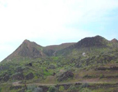
Montaña Amarilla Natural Monument is a singular cone of phreatomagmatic origin (an eruption in which lava comes into contact with water), partially demolished by sea erosion, which has uncovered a fossil dune situated between the lava structures of the sea cliffs. It is the southernmost in a line of volcanic cones, notable for the distinctive yellow colour of its volcanic materials and for having originated in an underwater eruption, of which there are few examples on the island.
Getting there
Montaña Amarilla Natural Monument can be accessed from the TF-1, exiting via the Las Chafiras-San Miguel-Los Abrigos junction and continuing along the TF-655. Shortly before reaching kilometre 2 of this road you will see another road leading towards the sea, the TF-652, which will take you to Guargacho. From Guargacho there is another asphalted road that leads directly to the Natural Monument.
You can also drive along the TF-652 towards the Costa del Silencio and take the turn-off that appears on the left-hand side around kilometre 5+800. At the end of this road you will also be in Montaña Amarilla.
Total area
27,8 ha.
Municipality
San Miguel and Arona.
Governing legislation
Montaña Amarilla was declared a Natural Monument and area of environmental sensitivity by Autonomous Region Act 12/94, which was later integrated into the Organisation of the Canary Islands Territory Act via Legislative Decree 1/2000.