What is it?
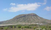
Montaña de Guaza Natural Monument is situated in the southernmost point of the island, to the northeast of Punta de Rasca. It is a volcanic cone whose slopes stretch down to the sea, forming the high cliffs known as the Mesas de Guaza. The area is notable for its populations of protected plant and animal life, including certain species of endemic reptiles.
Getting there
Montaña de Guaza Natural Monument can be accessed from the TF-1 via the exit for Los Cristianos, taking the TF-655 down towards the town. Keeping to the main road, after approximately 2.7 kilometres you will enter the village of Playa Graciosa, where you can park and enter the protected areas via any of the paths that provide access.
You can also enter the Natural Monument from the eastern side: to do so, take the exit for Guaza-Valle San Lorenzo-Las Galletas, follow the TF-6222 to the junction for El Palm-Mar and turn off towards the town. In El Palm-Mar, you will have to park and continue to the Natural Monument on foot via one of the paths.
Total area
725.7 ha.
Municipality
Arona.
Governing legislation
Montaña de Guaza was declared a Natural Monument and area of environmental sensitivity by Autonomous Region Act 12/94, which was later integrated into the Organisation of the Canary Islands Territory Act via Legislative Decree 1/2000.
 Print
Print