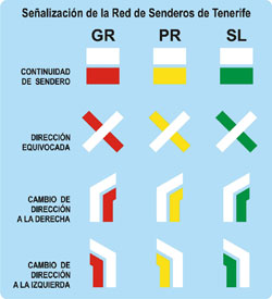
La Red de Senderos de Tenerife cuenta con tres tipos de rutas:
- Sendero de Gran Recorrido. Se identifica con los colores blanco y rojo, y con las siglas GR. Estos grandes trayectos se realizan en varias jornadas, dado que su longitud es superior a los 50 kilómetros.
- Sendero de Pequeño Recorrido. Se identifica con los colores blanco y amarillo, y con las siglas PR. Su longitud oscila entre los 10 y los 50 kilómetros; alguno de estos senderos poseen menos de 10 kilómetros, pero se han clasificado como PR debido a la pendiente del terreno, que añade mayor dificultad para la realización de la ruta.
- Sendero Local. Se identifica con los colores blanco y verde, y con las siglas SL. Su longitud es de menos de 10 kilómetros.
En la web www.tenerifeon.es y en la app Tenerife ON se pueden consultar las fichas de cada uno de los trayectos que conforman la Red de Senderos de Tenerife, así como las rutas para la realización de paseos a caballo, bicicleta o vehículos a motor, permitiendo entre otros servicios el de poder diseñar rutas personalizadas.
Para practicar actividades en el medio natural se recomienda consultar:
- Las posibles alertas meteorológicas,
- Las Resoluciones de activación de medidas para la prevención de incendios forestales
- Los cierres de senderos y de pistas forestales que se publican en la web www.tenerifeon.es y en la app Tenerife ON.
Contacto e Información
- Centro de Servicios al Ciudadano
- Dirección: Plaza de España, 3
38001, Santa Cruz de Tenerife - Teléfono: 922 239 500
- E-mail: 901501901@tenerife.es


 Print
Print