What it is?
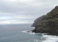
Costa de Acentejo Protected Landscape is an area of outstanding beauty, owing to the scenic qualities of its rugged, abrupt cliff faces. It is also a remarkable geomorphological landform and one that typifies the island's northern coastline, as well as being of scientific interest as a result of the endangered and protected plant and animal species that are found there.
There are two zones within Costa de Acentejo that have been categorised as areas of environmental sensitivity: one far to the northeast, in Bahía de La Garañona, and another far to the southewest, in Ancón.
Getting there
Costa de Acentejo can be accessed from a number of points, including: Mesa del Mar in Taraconte; El Sauzal, via the coastal access road in Rojas; Santa Úrsula, via the path that runs between the village of Las Manchas and Charco del Negro; and Ancón beach can be accessed from El Rincón in La Orotava.
Total area
159.9 ha.
Municipality
El Sauzal, La Matanza, La Victoria, Santa Úrsula, Tacoronte and La Orotava.
Governing legislation
Costa de Acentejo was declared a Protected Landscape by Autonomous Region Act 12/94, which was later integrated into the Organisation of the Canary Islands Territory Act via Legislative Decree 1/2000. The appendix to Act 12/94 declared two sections of the Protected Landscape to be areas of environmental sensitivity.
 Print
Print