What is it?
Teide National Park is the best example of a high mountain volcanic ecosystem in all of the Canary Islands. It also includes habitats where it snows in winter with varying degrees of severity owing to its orientation and height above sea level. The snow makes a significant contribution to key ecological processes, such as refilling the aquifers.
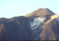
At an altitude of 2,000 to 3,717 metres, the Park also displays rare examples of high mountain shrubs and xerophytic plants adapted to arid environments. It is home to a variety of animal and plant species that are endemic to the Canary Islands, including an important number of invertebrates. Some species can only be found on Tenerife Island and others live exclusively in the Park. The Teide and Pico Viejo are known worldwide for the geomorphologic structure of the caldera and the towering stratovolcano (a tall, conical volcano built up by many layers of hardened lava, pyroclastic rock and volcanic ash). There are many more elements in the form of jagged peaks, caves and domes that enhance the area’s landscape and scientific interest.
The very nature of the Park's landscape makes it one of the most awe-inspiring parts of the Island, attracting millions of tourists every year. Some of the land on the outer edge of the National Park encroaches upon the Corona Forestal Nature Reserve.
Getting there
The main roads to Teide National Park are from La Esperanza, on the TF-24 (the Dorsal road); from Arafo, on the TF- 523 (Los Loros road); from La Orotava, on the TF-21; from Guía de Isora, on the TF-38; and from Vilaflor, on the TF-21.
Total area
18,990 Ha.
Municipal district
La Orotava, Guía de Isora, Adeje, Granadilla, Garachico, Icod de los Vinos, La Guancha, Santiago del Teide, Los Realejos, San Juan de la Rambla and Fasnia.
 Print
Print